Mid Coast Bush Fire Management Committee is to install Community Protection Plan Interpretive Signs for Pindimar, Bundabah, Hawks Nest and North Arm Cove.
From:
Inspector Ian Cook
Community Protection Planner
Planning & Environment Services (North)

The Royal Commission into the 2009, Victorian Black Saturday bush fires delivered a number of recommendations that reiterated the importance of educating the community on the most appropriate action to take prior to, and during a bush fire.
Your survival during a bush fire may depend on how prepared you and the community are. A community Protection Plan will help you make informed decisions on actions to take prior to and during a bush fire.
The aim of a Community Protection Plan is to:
- Empower communities to make decisions and take responsibility for their safety by increasing their understanding of bush fire threats and providing information that will assist in the preparation of personal Bush Fire Survival Plans;
- Identify, assess and depict contingency options available to a given community during a bush fire;
- Identify, assess and depict the range of timing of treatments applied to a given community that are designed to reduce the bush fire risk;
- Gather and depict key information that will increase the preparedness of fire fighters for bush fire.
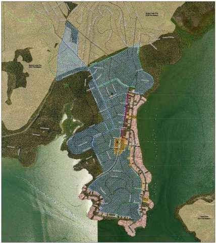
Community Protection Plans consist of three maps:
- Bush Fire Survival Map - includes information on the potential bush fire threat, the safety of access / egress provisions, early relocation options and contingency shelter options. This map provides information that can be used by members of the community when preparing their personal Bush Fire Survival Plan;
- Bush Fire Preparation Map - provides information for land managers, fire agencies and community members on details of the existing and proposed bush fire risk treatment works for the community. The map will also provide information that will prompt home owners / occupiers to take action to reduce their bush fire risk;
- Operational Brigade Map - provides brigades and other emergency services with important data relevant to the community to be used for operational purposes only.
The Interpretive signs will display the Bush Fire Survival and Bush Fire Preparation maps. The maps are visual
tools to assist the community make important decisions in preparing themselves in the event of bush fire.
The interpretive signs will be installed at the Community Hall (North Arm Cove), Curlew Ave, water front reserve area (Pindimar), the boat ramp reserve (Bundabah) and Providence Bay Park (Hawks Nest). I would encourage the community to make some time to view the interpretive signs and to consider their options and what they would do in the event of a bush fire.
Getting ready for a bush fire is easier than you think. Take the time to discuss what you will do during a fire with your family, you could save their lives as well as your home.
Having a well prepared home and a Bush Fire Survival Plan for the family is a smart move. Do not wait until it is too late
If you would like to know more about Community Protection Plans, Bush Fire Survival Plans or to find information on how to prepare your homes visit the NSW Rural Fire Service website: www.rfs.nsw.gov.au.
Alternatively if you would like to talk to a Community Protection Planning Officer you can call 66 910 400.
PLANNING & ENVIRONMENT SERVICES
NSW RURAL FIRE SERVICE
SUITE 1 /129 WEST HIGH STREET COFFS HARBOUR 2450
P: 02 66 910400 F: 02 66 910499