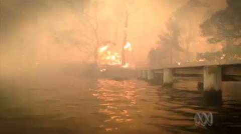
A letter recently published in the Cove News (February 2015) suggests that the provision of a jetty in the village may offer a much needed escape facility in the event of a bush fire. The proposition is based on media reports of the successful evacuation of people affected by the Tasman Peninsula bushfires of January 2013.
I have studied the reports in some detail and my understanding is that:
No lives were directly saved by boat evacuations from jetties.
Some people in Dunalley (the worst affected town) and in Murdunna were forced to take refuge by hiding in the water under jetties but they were not evacuated from them.
There is no evidence to suggest that rescue craft were prepared to approach the jetties in fire engulfed areas to save people.
The issue of marine evacuation has been a topic of discussion in the Cove for years. The NSW Fire Authority has investigated it in detail and held meetings with local groups. Rather than have old arguments re-surface, it's useful to consider the events of the Tasman Peninsular fires before concluding that escape by water is a viable option for us in the Cove.
There were a number of wildfires in the south of Tasmania at the time. The main fire headed from the north towards Dunalley on the Forestier Peninsula and was first reported at 2pm on 3 January. Many properties at Dunalley, Murdunna, Eaglehawk Neck (on the isthmus between the Forestier and Tasman Peninsulas and 20km from Dunalley), and Taranna (on the Tasman Peninsula) faced fires and there was much property lost.
The writer states that "the people rescued owed their lives to water evacuation" but the media reports cited describe people as stranded rather than facing an immediate fire threat endangering their lives.
The "2013 Tasmanian Bushfires Report" (dpac.tss.gov.au) confirms that evacuations by water of thousands began late at night on January 4, the day after the fire hit the peninsula. This was from Nubeena, a neighbourhood safer place on the west coast, not threatened by fire. Nubeena was inundated with locals and tourists from the Peninsula including 200 from Port Arthur (12km away). The facilities were overrun and boats started delivering meals, fuel, water and health workers.
Approximately 3-4000 of the stranded people were eventually ferried out which was a wonderful effort. These poor people were hungry, probably afraid and possibly homeless, but they were several kilometres from the firefront and the craft that rescued them were not subjected to thick smoke and burning embers.
At the height of the fire, some Tasman residents were forced to seek shelter in the water and under the wharf at Dunalley and at Murdunna. There is no report of them being rescued by boat. One person used a dinghy "when the inferno subsided" to move his family 200 metres to better air. One family had taken refuge in freezing water under a jetty, apparently for three hours. They reported that the smoke and embers reduced breathable airspace over the water to about 200-300mm (ABC broadcast, 7.1.2013), another factor that would severely handicap a marine evacuation.
There are very significant geographical and logistical differences between the Peninsula and North Arm Cove. The Tasman Peninsula covers hundreds of square kilometres. The Arthur Highway (the only exit to the north) was closed for over a week. Roads on the peninsula itself were not closed - there was a useful network of roads south of the fires.
At the Cove, we do not have the choice of alternative routes which makes our situation more dire.
If there is a fire in our region and access to the highway is closed, the fire is likely to be within 3-5km. The first threat will come from embers. Heading for the water would be an act of desperation. Mud along the eastern shore of the cove can extend for 40 metres on a low tide and the tide can drop over sharp rocks in the southern area.
In places our bush extends to the waterline. To assume that boats would be prepared to approach is overly-optimistic. They would be heading directly towards the fire and face smoke and embers with very low visibility and extreme oxygen depletion.
Part of the long discussion here has been where a jetty might be located. The GLC has identified potential jetty sites at Casuarina, Heros Beach and Medina Bay (our only real public deep water site). Should a preferred site be selected and a through-road be completed, would a single road be adequate for the many residents likely to be using cars? Where will everyone park? Who will be there to help any disabled person?
If we are unable to drive out of the village, why assume that we can drive or walk/run within the village to find a safe place in the water? And heading for the water on foot seems equally unwise even though it may be a best last option.
And this is the problem. Heading for the water may be a best last option but the presence of a jetty could easily give a false sense of security to the locals.
I for one totally support improved water access to the village and believe a jetty would be a wonderful asset for leisure users.
However, the warnings made by the NSW Fire Authorities against reliance on a jetty escape facility are not countered by citing the Tasmanian situation of 2013. We live in a bushfire-prone area and a personal Bushfire Survival Plan is a necessity. And this means early evacuation for most. The Fire Authorities have indicated that we may be on our own in a bushfire. We can't blame the absence of a jetty as a cause of heightened risk to our safety in a bushfire.
Pat Brennan


