Boat Trip to Allworth
This article continues the series of sightseeing on Port Stephens by boat from North Arm Cove. Our latest trip was up the Karuah River to Allworth in our 4.8 run-about with an 80hp motor. Our trip there and back took 4 hours and we used about 40 litres of fuel.
Our first port of call was Soldiers Point to fill up with fuel. We also had a nice morning tea at the coffee shop at the marina.
The wind was very light and the water surface was smooth, so we made good time heading west towards the Karuah River. There are two entrances to the Karuah River and we decided to use the southern entrance near Snapper Island. We had forgotten the binoculars and it was a bit difficult to find the correct channel markers, but we slowed down and eventually found the correct entrance. It helps to have a map showing numbered channel markers to ensure you are in the right spot. The channel is well marked all the way to Karuah.
The waterfront on he southeastern side of the road bridge at Karuah is very industrial with lots of oyster sheds. There is a jetty that says you can buy bait but we did not check whether it was open. If you wish to go ashore, you can also tie up at the swimming enclosure. There is a nice park adjacent to the road bridge and next to the swimming enclosure. It has picnic facilities, barbeques, toilets and children’s play equipment.
West of the bridge, there is a public boat launching ramp with a pontoon. Nearby is a derelict jetty and boat shed. There is nowhere to purchase fuel or food unless you walk to the shops in town.
Our boating map finished at the Karuah bridge. It had a notation that the river could be navigated for a further 11 nautical miles upstream. However, we also had a free Marine Park booklet which gave some details of the area upstream.
The water surface was smooth and it was about 2 hours after high tide. Our trip upstream was a bit slower than our return trip when we were cruising with the outgoing tide.
The Karuah settlement on the southern bank continues nearly all the way to the new highway bridge. After the highway bridge, the scenery is nearly all farmland and mangroves. Going under the highway bridge, the boating traffic is separated into two directions by the bridge pylons. Upstream traffic is directed to the north of the down stream traffic.
The river is wide and easy to navigate if you stay in the middle of the channel and watch out for hazards. We saw one partially submerged object that looked like a boat mast and there were two marked hazards, one marked with a yellow danger sign and the other with red tape. There are oyster racks along the shore on both sides of the river. The river becomes a Marine Park Habitat Protection Zone about half way between Karuah and Allworth.
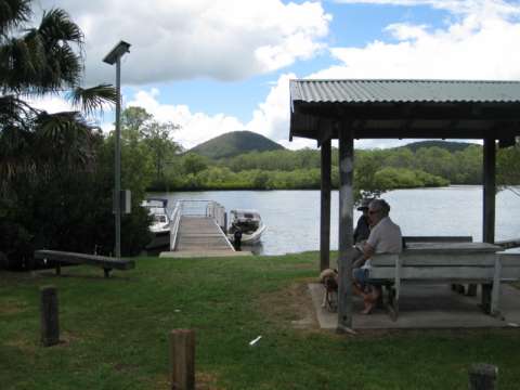
We continued all the way to Allworth. Allworth has a small public jetty with a picnic area. There is also a swimming enclosure a short distance upstream. We decided to stop for a quick snack at the picnic table adjacent to the jetty and also to let the dog off for a run. There are no toilet facilities or water, just a fish cleaning table.
There is a sign that says that navigation further upstream is hazardous due to submerged rocks and shallow water.
The channel at Allworth splits into two sections separated by a large privately owned island. The River is a Marine Park Sanctuary Zone ( no fishing) upstream of the Island. We decided to ignore the sign and travel around the island. We started off travelling upstream in the southern channel. We should have realised that it was time to retreat downstream when we saw a river gravel quarry on the southern bank near the upstream end of the island. All went well until we tried to get to the northern channel. At this point we hit some very large river stones and decided to retreat back to the southern channel. Talking to some locals back at the jetty, we were lucky that we didn’t get ourselves into some serious trouble. Apparently the northern channel has areas of shallow river bed with large stones and even the southern channel has several hazardous areas.
Inspection of our propeller showed no serious damage, so we headed off on our return trip. The outgoing tide made it a much quicker run. We made a short detour up the Branch River as far as Little Branch Creek. The Branch River is a Habitat Protection Zone and the Little Branch Creek is a Sanctuary Zone (no fishing). The scenery is still the same, farmland and mangroves.
Back at Karuah, we discovered that the wind had picked up and was blowing strongly from the east. We took the well marked northern channel back to the open water of Port Stephens. It was a very uncomfortable ride, with the wind opposing the tide. We arrived back to calmer waters on North Arm Cove and a rather late lunch.


