Port Stephens was named in honour of the Secretary to the Admiralty by Captain James Cook after he had sailed past the heads on 11 May 1770.
The first white people to enter Port Stephens were five convicts who in September 1790: escaped from the Parramatta settlement; stole a small boat and a week's supplies; and then sailed north. They were adopted by the Worimi people with whom they lived until they were discovered by HMS Providence in August 1795. The four surviving convicts had high praise for the "pacific disposition and gentle manners" of their Worimi hosts. (David Collins, An Account of the English Colony in New South Wales, Vol. 1, 1798)
Cedar cutting, which began around 1816, was the first industry in the area. Early settlement though really dates from 1826 when the Australian Agricultural Company was established at Carrington intending to produce fine wool for the British woollen mills. Tahlee House was built for the first manager of the Company, Robert Dawson, in 1826. A church, a school for around 50 children and a boat harbour were also constructed. By 1830 Carrington had a population of up to 500. At the time of first settlement the area was peopled almost entirely by the Worimi tribe. Harsh treatment by the settlers, depletion of food sources and introduced diseases decimated Aboriginal numbers. Sheep grazing was not successful, flocks were withdrawn by 1856, and the population of the area declined for a time.
Early plans for North Arm Cove could have led to a very different community to the quiet, rural village we have today.
A NSW Royal Commission established in 1899 considered the area between Balberook Cove and North Arm Cove as the sixteenth of forty potential sites for the Nation’s capital with plans to develop Port Stephens as a deepwater international port.
In 1911 another Royal Commission looking at “Decentralisation” recommended that Port Stephens be opened up. During WWI, the Federal Government acquired 1250 hectares for a naval base at Salamander Bay.
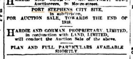
 On 6 May 1918 the American architect Walter Burley Griffin (best known for his role in designing Canberra) had a plan for Port Stephens City Site approved by Stroud Shire Council. This plan (see National Library of Australia http://nla.gov.au/nla.map-rm1650) centred on the region occupied by present day North Arm Cove village. It included wide green spaces along most of the shoreline. There was provision for jetties and wharves, civil, administration and service buildings and two railway stations linked to the main northern line. Advertisements soon after began appearing in the Sydney Morning Herald foreshadowing an auction of land at Port Stephens City towards the end of that year. This auction did not eventuate and similar ads appeared again in early 1919. Around this time Walter Burley Griffin's company went into liquidation and ownership of the subdivision passed to his friend Henry F Halloran.
![]()
SMH 2 Aug 1919
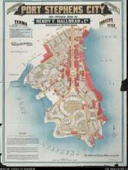 Halloran had trained as a surveyor but by 1900 had already become an innovative and entrepreneurial land developer. The Halloran plan for Port Stephens City had some significant changes from the approved May 1918 concept plan. These changes included removing the green fringe by adding Cove Boulevard (with new blocks of land on both sides of that road) and by adding further lots to the east of Eastslope Way, the west of Promontory Way and the south of The Esplanade. This increased the number of lots to some 2000. (See National Library of Australia http://nla.gov.au/nla.map-rm1651)
This was a boom period for development in Australia. Many lots sold quickly, particularly those along the foreshore. At the same time there were proposals approved to develop Pindimar City. None of these plans came to fruition. The planned naval base was built in Singapore. A Parliamentary Standing committee backed the port of Newcastle as the site for further development and Government funds ran low during the Great Depression of the 1930s.
In 1963, the Great Lakes Council closed most of the roads planned in the subdivision, setting aside a small area for residential expansion, and zoning the rest non-urban. The layout and signposts of some of the closed roads can still be seen in some of the undeveloped areas of the Cove.
In 1976/77 the waterfront land shown on the Halloran plan adjacent to Cove Gate Way began to move out of public hands. It was subdivided in 1989/90.
In addition to on-line sources referenced within the text, some information in this article has been drawn from:
- Great Lakes Council Heritage Study which was adopted in May 2007
- Mike Scanlon, City of Dreams Newcastle Herald, Saturday September 9, 2006
SMH Advertisements extracted from trove.nla.gov.au
(Some contributions to this article from dougk)